Ten Leesburg areas compared: ZIP code, zoned high school and Zillow home value for each, from downtown to Potomac Station, with links to a guide on every one.
Last checked Oct. 20, 2026. Sources: the Town of Leesburg’s GIS layers (town limits, business districts, Crescent District, trash collection areas), Loudoun County’s residential communities map and address points, Loudoun County Public Schools’ 2026-27 high school zones, the Virginia Department of Education’s School Quality Profiles, Zillow Research, the Census Bureau and OpenStreetMap.
Leesburg is the Loudoun County seat, a town of about 13.3 square miles built outward from its historic downtown at King Street (U.S. 15 Business) and Market Street (Route 7 Business). The Leesburg Bypass, U.S. 15 and Route 7, loops around the older town; many of the planned communities are outside that loop, east toward Ashburn along Route 7 and south toward the Dulles Greenway. Town street addresses carry a quadrant: NE, NW, SE or SW.
Leesburg had 49,171 residents in the Census Bureau’s 2020-2024 American Community Survey, with a median household income of $145,205. See the town’s QuickFacts page and our population guide.
What this means for you
- Two ZIP codes, 20176 north and 20175 south, and both reach outside the town. A Leesburg mailing address does not always mean a home is in the town, where owners pay the town’s real estate tax in addition to the county’s and get town trash pickup.
- Three zoned high schools, Heritage, Loudoun County and Tuscarora. Their zones do not follow the town line or the ZIP codes. Check any address in Loudoun County Public Schools’ LABEL lookup.
- Home values in both ZIP codes were about $827,000 to $829,000 in September 2026, according to the Zillow Home Value Index.
The areas at a glance
| Area | ZIP code | Zoned high school | Typical home value in its ZIP, September 2026 | Guide |
|---|---|---|---|---|
| Downtown | 20175 and 20176 | Tuscarora (nearly all) | $827,121 (20175); $828,624 (20176) | Downtown |
| Crescent District | 20175 (most) and 20176 | Tuscarora, Loudoun County or Heritage | $827,121 (20175) | Crescent District |
| Exeter | 20176 | Tuscarora | $828,624 | Exeter |
| Potomac Crossing | 20176 | Tuscarora | $828,624 | Potomac Crossing |
| Potomac Station | 20176 | Heritage | $828,624 | Potomac Station |
| Village at Leesburg | 20175 | Heritage | $827,121 | Village at Leesburg |
| Kincaid Forest | 20175 | Heritage | $827,121 | Kincaid Forest |
| Tavistock Farms | 20175 | Heritage | $827,121 | Tavistock Farms |
| Stratford | 20175 | Heritage | $827,121 | Stratford |
| Greenway Farm | 20175 | Loudoun County | $827,121 | Greenway Farm |
Zillow’s index is a modeled value for the middle third of homes, not a sale price. The figure for Leesburg as a whole was $848,639. All three high schools were rated Distinguished and Fully Accredited by the Virginia Department of Education for 2025-26: Heritage scored 94.7, Tuscarora 90.21 and Loudoun County 90.1. More in our home prices guide and schools guide.
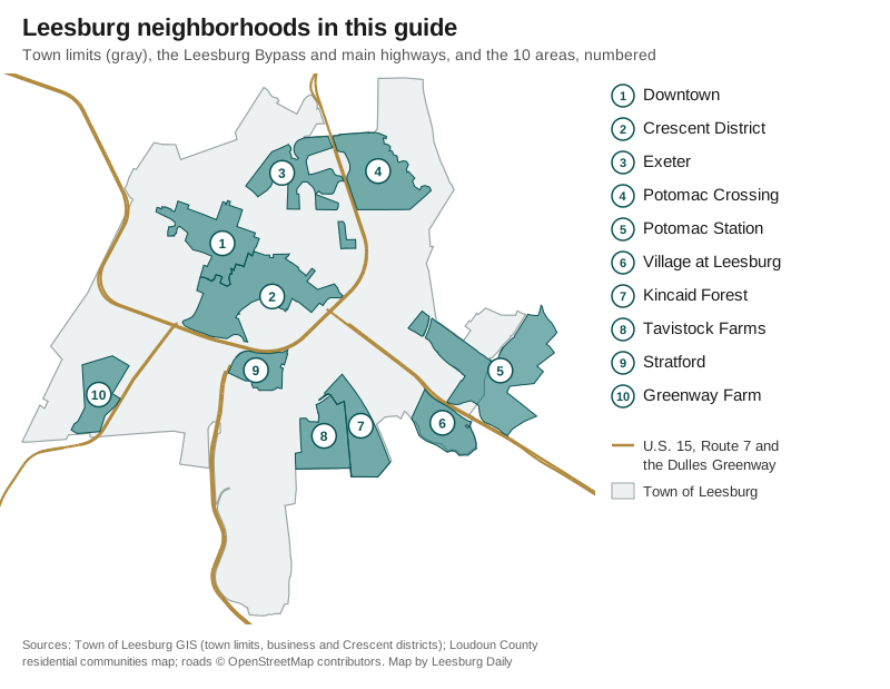
Map by Leesburg Daily from Town of Leesburg and Loudoun County GIS data; roads © OpenStreetMap contributors.
Inside the bypass
Downtown is the town’s 258-acre Historic Downtown business district around King and Market streets, nearly all of it inside the Old and Historic District. It has four small town parks and the W&OD Trail, and most addresses are zoned for Tuscarora High.
The Crescent District is the 403-acre band of corridors along Catoctin Circle, East Market Street and South King Street that curves around downtown. It has supermarkets on its main roads, Olde Izaak Walton Park and Raflo Park, and it is split among all three high school zones.
Exeter, in north Leesburg off Battlefield Parkway and Catoctin Circle, has 940 homes on the county’s map and Robinson Park inside it. It is zoned for Tuscarora High and about 1.1 miles by road from downtown.
North and east
Potomac Crossing, in the northeast corner outside the U.S. 15 bypass, has 926 homes and borders Ball’s Bluff Battlefield Regional Park. Every address is zoned for Ball’s Bluff Elementary and Tuscarora High.
Potomac Station, north of Route 7 at Battlefield Parkway, is the largest community in this guide, with 1,553 homes on the county’s map. The town line runs through it: about half its addresses are in unincorporated Loudoun County. It is zoned for Heritage High.
The Village at Leesburg, south of Route 7 at Crosstrail Boulevard, is a mixed-use development with 559 homes, mostly multifamily, a Wegmans and a fare-free bus route inside it. It is zoned for Heritage High.
South of the bypass
Kincaid Forest (536 homes) and Tavistock Farms (518 homes, plus 150 at Somerset Park) sit side by side along Battlefield Parkway SE, with Tuscarora Park and the W&OD Trail at their edge. Both are zoned for Cool Spring Elementary and Heritage High.
Stratford, off Sycolin Road SE just south of the bypass, has 662 homes, from detached houses to 300 multifamily homes. It is zoned for Heritage High and is about 1.1 miles from Dulles Greenway exit 2.
Greenway Farm, west of South King Street (U.S. 15), has 408 homes and Greenway Farms Park inside it. It is the one area in this guide zoned for Loudoun County High.
Other named communities
Loudoun County’s residential communities map names dozens of smaller communities inside the town limits that this guide does not profile separately. The largest, by the county’s July 2025 count, include Sycamore Hill (475 townhouses), Fields of Leesburg (409 multifamily homes), Meadowbrook Farm Estates (398 houses), Edwards Landing (385), Windsor at Fieldstone (384 multifamily), The Manor (363 multifamily), Leesburg Country Club (343 houses), Stowers (330 houses), Oaklawn (270 townhouses), Exeter Hills (256 houses), Foxridge (208 houses) and Prospect Hills (185 houses). Check any of them in the county’s parcel and map viewer, WebLogis.
Comparing Leesburg with its neighbors
For taxes, schools, home values and commute times in Leesburg, Purcellville, Ashburn and Brambleton side by side, see Leesburg vs. Purcellville vs. Ashburn vs. Brambleton. New to town? Start with our moving to Leesburg guide.
How we built this guide
We chose areas that a public map names and outlines, so each page can be checked. Downtown and the Crescent District are the Town of Leesburg’s own district boundaries from its GIS service. The other eight are communities outlined on Loudoun County’s residential communities map (July 2025 counts), each also named as a place by OpenStreetMap. We left out areas without a mapped outline. School zones, ZIP codes and trash collection days come from laying Loudoun County Public Schools’ 2026-27 attendance zones, Census ZIP code areas and the town’s layers over the county’s address points. Distances are measured on the OpenStreetMap road network with the OSRM routing engine and are not drive times. Map data and store locations are © OpenStreetMap contributors.
Frequently asked questions
What are the neighborhoods in Leesburg, Virginia?
This guide covers 10 areas named on the town’s or Loudoun County’s maps: Downtown, the Crescent District, Exeter, Potomac Crossing, Potomac Station, the Village at Leesburg, Kincaid Forest, Tavistock Farms, Stratford and Greenway Farm.
What ZIP codes are in Leesburg?
Two cover the town: 20176 for the north side and 20175 for the south, with Market Street roughly dividing them downtown. Both also reach outside the town limits.
Which high school is my Leesburg address zoned for?
One of three: Heritage, Loudoun County or Tuscarora High, all run by Loudoun County Public Schools. The zones do not follow the town line, so check the address in the district’s LABEL lookup.
Is every Leesburg address inside the town limits?
No. Leesburg mailing addresses reach into unincorporated Loudoun County. Potomac Station, for one, is split: about half its addresses are in town and half in the county, which affects taxes and trash pickup.
Have your say